Celebrating the ‘treasures’ in McMaster’s maps collection
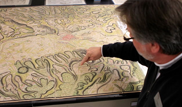
Gord Beck, Maps Specialist at Mills Library, explains the significance of one of the many rare and unique maps on display at a recent event celebrating the 50th anniversary of the Lloyd Reeds Maps Collection.
Shortly after arriving at McMaster in 1948, geography professor, Lloyd George Reeds, who would one day be regarded as one of the ‘founding fathers’ of Canadian geography, began looking for space to house his growing collection of maps.
At that time, he settled for an old temporary building on campus, described by one observer as a ‘war-time hut,’ but he dreamed of one day creating a physical space that would contain and preserve his maps for the purposes of teaching and research.
In 1965, Reeds’ dream was finally realized and the Lloyd Reeds Maps Collection, as it would later become known, opened its doors.*
Members of the McMaster community gathered recently in Mills Library, which currently houses the collection, to mark the 50th anniversary of this important milestone and to celebrate the unique and extensive materials that now make up the collection.
“For 50 years, the Lloyd Reeds Maps Collection has been providing students and faculty with hand-on access to these rich research and teaching tools,” says Dale Askey, Associate University Librarian. “As we look ahead, perhaps to the next 50 years, we look forward to acquiring more unique pieces, as well as finding new ways to connect scholars, both at McMaster and around the globe, with these treasures.”
The collection, which originally contained Reeds’ personal maps including maps on the agricultural geography of Southern Ontario, has grown significantly over the years, and now consists of more than 130,000 sheet maps, 18,000 air photos, 3,000 atlases, and many more materials.
“We have something for everyone,” says Gord Beck, Maps Specialist, Mills Library. “We have everything from historical maps that inform cultural studies, to hydrographic and aeronautic charts. Then, of course, we have many maps created for military purposes; the great WWI and WWII collections, as well as maps from the Napoleonic era and earlier.”
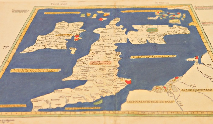
Many rarely seen, hidden gems were on the display at the event, including the oldest map in the collection, a 1486 reproduction of a map by Ptolemy of the British Isles.
Over the years, the collection has become a valuable resource for teaching and learning. According to Jay Brodeur, Manager- Maps, Data, GIS, about 2000 undergraduates from a number of disciplines come into the space each year to work hands-on with the materials.
The collection is also being made available to scholars around the world. In the last five years, 7000 maps have been scanned and are available through the Library’s Digital Archive, attracting thousands of users annually.
“The collection and the staff have established themselves as leaders nationally in the area of map digitalization,” says Brodeur. “Through the process of scanning these maps, describing them and making them available online, we are able to change the way users interact with the materials. Instead of people coming to McMaster, we are increasingly able to bring our collection to students and researchers from around the world.”
*It was in 1965 that administration of the Lloyd Reeds Maps Collection was officially handed over to McMaster University Library.
